
land grading Camas WA planning should begin with the finished property, not with the first machine task. Owners often call because trees, standing water, rough ground, a failed driveway or an underground route is blocking progress. The visible issue matters, but the lasting result depends on what comes next: a home, shop, utility, septic system, landscape, access road or drainage outlet. A site-specific plan connects today’s excavation work to that long-term use.
Acre Maker provides professional land grading services for homeowners, builders and property owners across Southwest Washington. The team can evaluate the property, clarify the groundwork scope and coordinate related clearing, grading, access, trenching or excavation. Property owners can request a project estimate after gathering any plans, surveys, utility information and jurisdictional requirements available for the site.
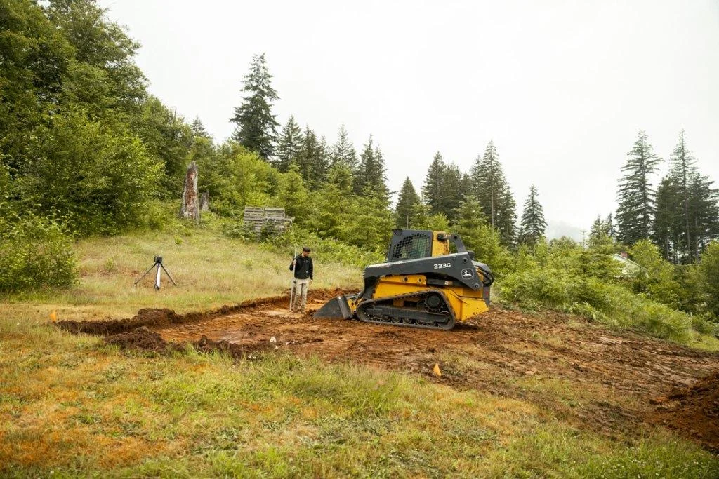
Acre Maker checking elevations before shaping a sloped building area. Image source: Acre Maker website
Why land grading Camas WA Requires a Property-Specific Plan
Camas sites can transition quickly from upland ground to steep slopes and drainage corridors. On these properties, a flat pad is only one part of the solution. The transitions above and below the pad, access grade, retaining needs, roof runoff and stabilized outlet determine whether the finished site performs through wet weather.
The practical questions are consistent: What must remain protected? Where can equipment travel? Which elevations are fixed? Where will water go? What material is suitable for reuse? What inspections or approvals occur before work is covered? Answering those questions early helps a Camas, WA property move from an isolated excavation task to a coordinated, buildable result.
1. Establish Existing and Finished Elevations
The first useful step is to define the outcome before moving equipment. On a Camas, WA property, a concept that says “make it level” does not explain how the new pad connects to the road, house, utilities and downhill ground. During the site walk, the contractor should survey or verify key elevations, slope breaks, drainage paths and proposed finished floor or surface heights. That information helps determine the equipment, access route, material handling, and order of operations needed for the work. For a land grading Camas WA project, this early evaluation is especially important because the visible problem is often connected to drainage, soil condition, buried infrastructure, or a future phase of construction.
A sound recommendation is to create a grading plan with measurable contours and transitions. The scope should identify what will be removed or reshaped, what will remain protected, where excavated material will go, and what condition the area should be in at handoff. If the plan skips that level of detail, the site may be flat in the center but too steep, wet or inaccessible around the edges. Clear benchmarks also make it easier to coordinate land grading with surveyors, builders, utility providers, septic professionals, or landscape crews without repeating work.
2. Balance Cut and Fill Intentionally
A dependable plan separates what is visible on the surface from what controls performance below it. On a Camas, WA property, excavated soil varies in suitability and the volume expands when loosened. During the site walk, the contractor should estimate cut, usable fill, unsuitable soil, topsoil and required import or export. That information helps determine the equipment, access route, material handling, and order of operations needed for the work. For a land grading Camas WA project, this early evaluation is especially important because the visible problem is often connected to drainage, soil condition, buried infrastructure, or a future phase of construction.
A sound recommendation is to separate materials and place only suitable fill in structural zones. The scope should identify what will be removed or reshaped, what will remain protected, where excavated material will go, and what condition the area should be in at handoff. If the plan skips that level of detail, unexpected export, buried organics or poor fill can disrupt budget and performance. Clear benchmarks also make it easier to coordinate land grading with surveyors, builders, utility providers, septic professionals, or landscape crews without repeating work.
3. Prepare the Fill Foundation
This decision should be made during field evaluation, not after excavation has already started. On a Camas, WA property, placing fill over vegetation, topsoil, soft pockets or a steep unkeyed slope can lead to movement. During the site walk, the contractor should strip unsuitable material and evaluate how new fill will bond to existing ground. That information helps determine the equipment, access route, material handling, and order of operations needed for the work. For a land grading Camas WA project, this early evaluation is especially important because the visible problem is often connected to drainage, soil condition, buried infrastructure, or a future phase of construction.
A sound recommendation is to bench, key and compact fill as required by the project design and soil conditions. The scope should identify what will be removed or reshaped, what will remain protected, where excavated material will go, and what condition the area should be in at handoff. If the plan skips that level of detail, the finished slope or pad can settle, creep or crack after construction. Clear benchmarks also make it easier to coordinate land grading with surveyors, builders, utility providers, septic professionals, or landscape crews without repeating work.
4. Control Water From Uphill
The goal is not simply to move soil or material; it is to create a site that supports the next phase. On a Camas, WA property, runoff arriving from above the work area can cross the pad or saturate fill. During the site walk, the contractor should identify contributing slopes, roadside flow, roof runoff and natural swales. That information helps determine the equipment, access route, material handling, and order of operations needed for the work. For a land grading Camas WA project, this early evaluation is especially important because the visible problem is often connected to drainage, soil condition, buried infrastructure, or a future phase of construction.
A sound recommendation is to intercept and route water through a stable system before it reaches vulnerable grades. The scope should identify what will be removed or reshaped, what will remain protected, where excavated material will go, and what condition the area should be in at handoff. If the plan skips that level of detail, newly placed soil can erode or remain saturated even when the pad itself is shaped correctly. Clear benchmarks also make it easier to coordinate land grading with surveyors, builders, utility providers, septic professionals, or landscape crews without repeating work.

Equipment operator view during grading and surface preparation. Image source: Acre Maker website
5. Design a Stable Downhill Outlet
Good site work is measured by how well the property functions after the equipment leaves. On a Camas, WA property, concentrated discharge gains energy on a steep property. During the site walk, the contractor should inspect the entire route to the receiving area, not just the first few feet of pipe or swale. That information helps determine the equipment, access route, material handling, and order of operations needed for the work. For a land grading Camas WA project, this early evaluation is especially important because the visible problem is often connected to drainage, soil condition, buried infrastructure, or a future phase of construction.
A sound recommendation is to spread, armor or otherwise stabilize the outlet according to the site conditions and approved plan. The scope should identify what will be removed or reshaped, what will remain protected, where excavated material will go, and what condition the area should be in at handoff. If the plan skips that level of detail, water can cut gullies, undermine slopes or affect neighboring property. Clear benchmarks also make it easier to coordinate land grading with surveyors, builders, utility providers, septic professionals, or landscape crews without repeating work.
6. Coordinate Retaining and Grading Decisions
A practical scope connects today’s work to the driveway, building, utility, drainage, or landscape work that follows. On a Camas, WA property, trying to avoid all retaining can consume land, while adding walls late can change drainage and access. During the site walk, the contractor should compare safe slope transitions with engineered retaining options early. That information helps determine the equipment, access route, material handling, and order of operations needed for the work. For a land grading Camas WA project, this early evaluation is especially important because the visible problem is often connected to drainage, soil condition, buried infrastructure, or a future phase of construction.
A sound recommendation is to choose the solution that fits space, budget, maintenance and project approvals. The scope should identify what will be removed or reshaped, what will remain protected, where excavated material will go, and what condition the area should be in at handoff. If the plan skips that level of detail, last-minute walls or overly steep slopes create redesign and permit delays. Clear benchmarks also make it easier to coordinate land grading with surveyors, builders, utility providers, septic professionals, or landscape crews without repeating work.
7. Plan Construction Access and Sequencing
The best time to solve this issue is while access, elevations, and equipment sequencing are still flexible. On a Camas, WA property, equipment needs safe working room while the site is changing elevation. During the site walk, the contractor should identify temporary haul routes, turning areas, stockpiles and a sequence from rough cut to final grade. That information helps determine the equipment, access route, material handling, and order of operations needed for the work. For a land grading Camas WA project, this early evaluation is especially important because the visible problem is often connected to drainage, soil condition, buried infrastructure, or a future phase of construction.
A sound recommendation is to keep clean and dirty traffic organized and protect completed work. The scope should identify what will be removed or reshaped, what will remain protected, where excavated material will go, and what condition the area should be in at handoff. If the plan skips that level of detail, machines may track over finished fill, trap themselves downhill or repeatedly disturb stabilized soil. Clear benchmarks also make it easier to coordinate land grading with surveyors, builders, utility providers, septic professionals, or landscape crews without repeating work.
8. Stabilize the Site Before the Rain
A written field plan gives the owner and contractor the same definition of a finished result. On a Camas, WA property, bare cut faces and fresh fill erode quickly during intense or prolonged rain. During the site walk, the contractor should schedule temporary cover, perimeter controls and final stabilization with the grading work. That information helps determine the equipment, access route, material handling, and order of operations needed for the work. For a land grading Camas WA project, this early evaluation is especially important because the visible problem is often connected to drainage, soil condition, buried infrastructure, or a future phase of construction.
A sound recommendation is to treat erosion control as part of production, not an optional cleanup item. The scope should identify what will be removed or reshaped, what will remain protected, where excavated material will go, and what condition the area should be in at handoff. If the plan skips that level of detail, sediment can leave the site and the carefully shaped grades can wash out. Clear benchmarks also make it easier to coordinate land grading with surveyors, builders, utility providers, septic professionals, or landscape crews without repeating work.
How Acre Maker Approaches Land Grading Projects
Acre Maker evaluates grading as a water-and-elevation problem, not merely a request to make an area look smooth. The site walk should identify high points, low points, runoff sources, soil condition, outlets, structures and future improvements. Measurements and a clear finish plan guide where soil is cut, placed, compacted or removed.
The work should also include temporary drainage and stabilization so the property remains functional between rough grading and final landscaping or construction. When drainage, driveway and site-preparation work overlap, one coordinated plan helps every surface connect.
Learn more about Acre Maker’s start-to-finish groundwork services and the company’s commitment to local communication and dependable field work on the About Acre Maker page.
What a Complete Contractor Proposal Should Address
A useful proposal for land grading Camas WA should define limits, quantities, exclusions and the condition of the finished site. Look for descriptions of mobilization, access, protection, clearing or excavation limits, soil and material handling, import or export, drainage, compaction, cleanup and restoration. The proposal should identify owner-provided information, permit responsibility, utility locating, inspections, schedule assumptions and conditions that could trigger a documented change. Comparing that scope is more reliable than comparing a single price with no shared definition of completion.
Ask how weather, unsuitable soil, buried debris, rock, groundwater, unmarked private utilities or design changes will be handled. A contractor cannot eliminate every unknown below the surface, but the agreement can establish communication, documentation and decision-making procedures before those unknowns affect the work.
A Practical land grading Camas WA Planning Checklist
- Verify existing and proposed elevations.
- Estimate cut, fill, topsoil and export volumes.
- Remove unsuitable organic and soft material.
- Plan compaction and testing where required.
- Intercept runoff from uphill areas.
- Create a stable downhill discharge route.
- Coordinate retaining, utilities and access.
- Install erosion controls and final stabilization.
Frequently Asked Questions
Can all excavated soil be reused as fill?
No. Suitability depends on soil type, moisture, organics, rock content and the intended use of the fill area.
Does a sloped lot always require retaining walls?
Not always. Available space and safe slope geometry may allow graded transitions, while tight sites or large elevation changes may require engineered retaining.
Why is compaction important?
Properly placed and compacted fill reduces settlement and creates dependable support for drives, pads and other improvements.
Where should uphill water go?
It must be routed to a lawful, stable outlet based on site conditions and applicable requirements; it should not simply be redirected toward a neighbor or structure.
When should a grading contractor join the project?
Early, while building placement, access, utilities, retaining and drainage can still be coordinated.
Plan Your Camas, WA Groundwork With Acre Maker
Successful land grading Camas WA work creates more than a temporary visual improvement. It should make the property safer, easier to build on, better drained and ready for the next trade or long-term use. Acre Maker helps Southwest Washington property owners connect field conditions with a clear scope for land grading. To discuss the property, intended use and next steps, contact Acre Maker for a project estimate.
External Sources
- Clark County – Erosion Control
- Washington State Department of Ecology – Construction Stormwater Permit
- WSU Extension Clark County – Improving Drainage
Image Credits
- land grading Camas WA sloped lot survey and elevation layout – Acre Maker website
- sloped lot grading and compaction in Camas WA – Acre Maker website